Back مقاطعة جيتور Arabic مقاطعه جيتور ARZ चित्तूर जिला Bihari চিত্তুর জেলা Bengali/Bangla Chittoor (distrito) CEB Chittoor (distrikt) Danish Chittoor (Distrikt) German Distrito de Chittoor Spanish Chittoor barrutia Basque بخش چتور Persian
Chittoor district | |
|---|---|
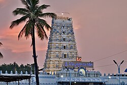
 Galigopuram of Vinayaka Temple, Kanipakam | |
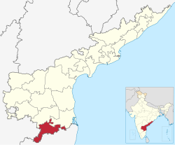
 Location of Chittoor district in Andhra Pradesh | |
 | |
| Coordinates: 13°12′58″N 79°05′49″E / 13.216°N 79.097°E | |
| Country | |
| State | |
| Region | Rayalaseema |
| Formed | 1 April 1911 |
| Reorganized | 4 April 2022 |
| Headquarters | Chittoor |
| Largest City | Chittoor |
| Government | |
| • District collector | Sumith kumar, IAS |
| • SP | V N Manikanta chendolu, IPS |
| • Lok Sabha | Lok Sabha list |
| • Assembly | Assembly list |
| Area | |
| • Total | 6,855 km2 (2,647 sq mi) |
| Population | |
| • Total | 1,872,951 |
| • Sex ratio | 985 (females per 1,000 males) |
| Languages | |
| • Official | Telugu |
| • Regional | |
| Time zone | UTC+5:30 (IST) |
| Postal Index Number | 517xxx |
| Area codes | +91–8572 |
| ISO 3166 code | IN-AP |
| Vehicle registration | AP-03 (former) AP–39 (from 30 January 2019)[5] |
| Website | chittoor |
Chittoor district () is one of the eight districts in the Rayalaseema region of the Indian state of Andhra Pradesh. It had a population of 18,72,951 at the 2011 census of India.[6] It is a major market centre for mangoes, grains, sugarcane, and peanuts. The district headquarters is at Chittoor City. The major cities/towns in the district are Chittoor, Punganur, Nagari, Palamaner, and Kuppam.
- ^ a b "Demography". Chittoor district. Retrieved 13 April 2023.
- ^ a b c d e Cite error: The named reference
censuswas invoked but never defined (see the help page). - ^ "District Census Hand Book - Chittoor" (PDF). Census of India. Registrar General and Census Commissioner of India.
- ^ "Table C-16 Population by Mother Tongue: Andhra Pradesh". Census of India. Registrar General and Census Commissioner of India.
- ^ "New 'AP 39' code to register vehicles in Andhra Pradesh launched". The New Indian Express. Vijayawada. 31 January 2019. Archived from the original on 21 November 2020. Retrieved 9 June 2019.
- ^ "Census of India 2011" (PDF). censusindia.gov.in.